
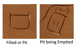
All of the items on the Trail stone map and Heart map were found to be represented with surveyed accuracy, but the meaning of one item could not be figured out, and that was the horseshoe shape around the 2 short lines.
This has been given short periods of thought for over a decade, and finally it occurred what the symbol represents. It represents a filled-in pit. The map creator is trying to tell you that you have to empty out the filled-in pits that are located on the 2 ridges to get to the treasure at the bottom. Below is a diagram showing the filled-in pit before it is emptied and after.
These pits have been proven by seismic surveys which were also posted here.
So who created the stone maps? A recent trip to the Superstition Mountain Museum, and a close examination of the Stone Maps resulted in a very surprising observation. On the top edge of the Horse Stone Map is chiseled the tiny name “Miguel”. This author did not know this before.
By many accounts, Don Miguel was the sole survivor, or one of the few survivors of 1847/1848 expedition. See below for a photo of Miguel’s signature. It can be seen that the name is worn, possibly from carrying the stone in saddle bags for a long distance.

Miguel’s message was to simply empty the pits to reveal the ore that others had stopped mining.
How can this Peralta Stone Maps mystery be solved without further question? Where lies the truth? It is suggested that the answer lies with the material that the Stone Maps are made of. It has been written by all that the Trail Stone Map and Heart Stone Map are made of sandstone. It is suggested that this is not so. Sandstone consists of grains of sand that are mechanically deposited. It is postulated that the stones are really made of a rock called saccharoidal silica (sugar-like) that is an exhalative of VMS ore deposits. This material consists of grains of sand that are chemically deposited at a hot spring or underwater. Under magnification, the grains are crystal clear and are cemented together with iron oxide. Below is a photo of an iron-rich hot spring likely having saccharoidal silica.

Testing the theory regarding the Trail Stone Map and Heart Stone’s material, a piece of saccharoidal silica was taken from the ridges area indicated by the Trail Stone Map to the museum to compare to the Map and Heart Stone maps. This is what the comparison looks like (the hand-held specimen is redder on a fresh face):
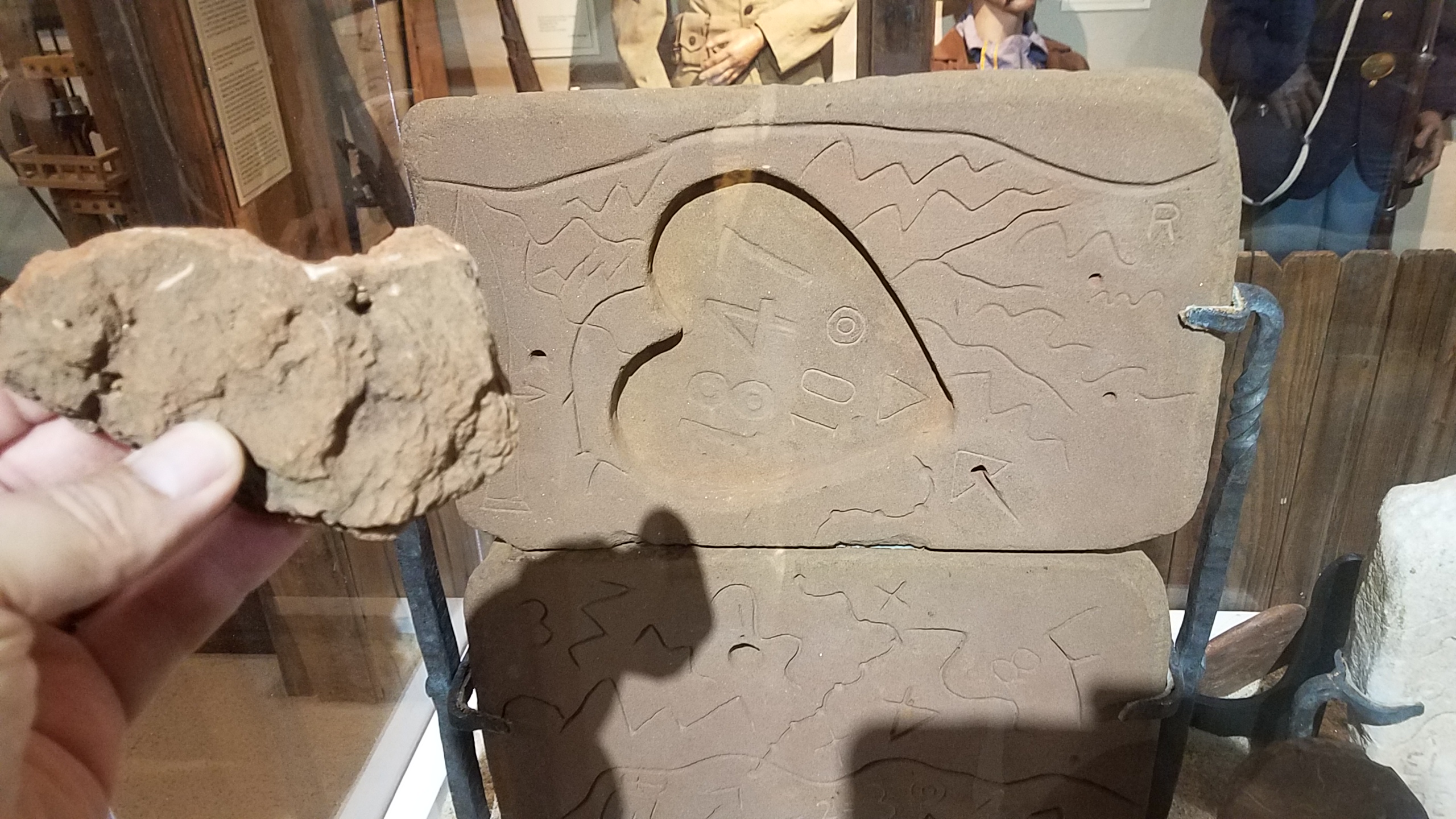
As you can see, they appear nearly identical in color, and from 2 feet away, the Trail Stone map and the handheld specimen appear to be the same rock. All samples retrieved from the two ridges carve very easily and accurately. A chisel is not needed as was used on the Horse Stone.
It is guessed that when the pits were filled back in with the overburden that once overlaid the ore, there were larger pieces of the saccharoidal silica available, but large pieces were still rare. It appears that the Trail and Heart Stones were made from the same piece of rock that was split on a bedding plane. The Horse Stone had to be made from a harder piece of real sandstone because there was not another large piece of saccharoidal silica available. The Horse Stone was chiseled.
A Petrologist or Mineralogist with a loupe should be able to answer the question regarding the rock the Trail Stone and Heart Stone are constructed of in a couple of minutes.
There has been a new development in seismic surveying that will make the mapping of all of the pits the Spanish, Mexicans, and possibly pre-Columbian people have dug and filled back in a very easy task. No geophone cables, surveying or hammering is necessary. It is called a passive seismic system. The system is made by Geometrics, the same company that the gear was rented from for the seismic surveys of the Molly Marie Prospect. The new device is called the "Atom". It is small, has a great amount of memory and has built in GPS. You set it on the ground and it gives depth to bedrock. No set spacing is needed. Before too long, there may some filled-in pits identified in the Goldfield area.
cuzzinjack