Hello Joe & Mike,
I re-read this thread and it made my head hurt. There a few things I take issue with:
• There are cobbles of soft sandstone and limestone on the west ridges on the Molly Marie Prospect. In fact, it appears by looking at the weathered texture on the “Don” side of the map stone that it was made from one of these cobbles.
• I agree with Mike concerning the subject of Tumlinson creating them to defraud. Creating them to defraud just doesn’t compute.
• I will meet some doubters halfway though, and do believe that Tumlinson “defaced” the Map Stone by scratching the formula on it. Maybe he wanted the stone to look more intriguing; I don’t know, but the scratchings do not match the rest of the map.
• We will never know the full truth, but one thing is for sure, the Map and Heart Stone are dead on in their description of a location. The odds of them describing any place else are infinitesimally small.
I have shown this link before, but to make telling the story easier, here it is again:
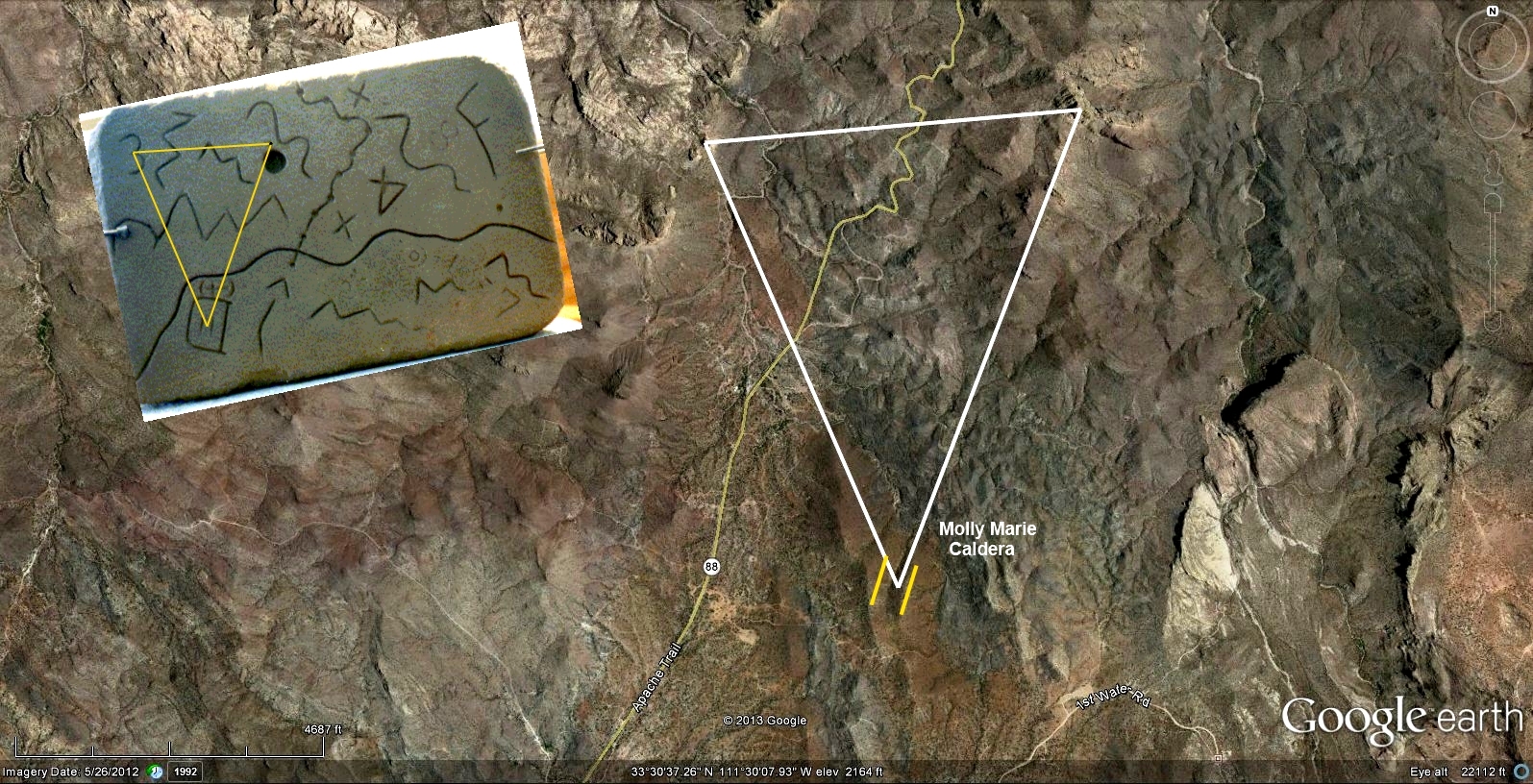
http://mollymarieprospect.com/Peralta2p ... angle2.JPG
About 9 years ago, my parents visited here from Wyoming. My dad went out to my claims with me and I showed him my recent discovery with the Map Stone.(an earlier post) My dad was a sharp cookie and he was very intrigued by what I’d found. At the time, neither of us knew anything about pits or the breccias there… but my dad knew prospecting, and had taken my brother and I all over NV in and out of mines when we were kids, and had even taken a graduate course in hydrology at UNLV(and did well).
We were standing in the middle of the west ridge near where the southern tip of the triangle was located in the above linked map, and decided to walk downhill to the west and into the gulch. I walked to the southwest, and my dad walked to the northwest. We were just looking around slowly and I meandered back to where my dad was. It was a wet spring, and the grass in the area was deep; it was about 2’ high.
I met up with my dad, and he said he had jumped the biggest mule deer buck he had ever seen. That was saying something, since he had hunted deer for almost all of his 70 years. He showed me his bed in the deep grass. We continued looking around, and we agreed that whole hillside had been disturbed. We wondered what had happened since we both knew mines and mining. We agreed that the exceptional grass may have been due to the soil being disturbed, which happens in reclaimed areas of the coal mines in Wyoming. My dad was becoming more intrigued, and I just happened to have a shovel. He started digging towards the north end of the grassy area and he calls me over.
He was very puzzled why the ground was digging so easily and why it was so sandy. He did not have a pick and the hole was going down fast. I jumped in and started digging. The ground started tightening up as the ground started to get dry, but there were few rocks. We left for the day.
A week later, my parents are back home and my father had fallen ill….. fevers, fevers, fevers. He went to the hospital and they were no help. We diagnosed it on-line as valley fever. Finally, after some threatening, the hospital gave him the medicine; they had never had a case before and were hesitant to give him the cure. He survived the valley fever, but he swore that the disease took out his knees, and he had pain walking ever after.
Now, fast forward a few years. I had learned how to recognize the breccias somewhat and contacted a major mining company. One of their best contacted me, and I sent him some photos; I don’t believe I had the website yet. He met me early one morning in the Needle Overlook parking lot, and after introductions, pulled out an 8-1/2 x 11 glossy of a piece of breccia I had sent him a photo of, and he said “Show me where this came from.” This is the photo I had sent him:
http://mollymarieprospect.com/Photos/bestbreccia.jpg
This is not cut, polished, etc., it is just the way it was found. I did not know at the time that this kind of breccia is the “Viagra” of the explorationist’s world. This sample speaks volumes for the preparation that occurred and what is necessary to create the environment needed for a substantial orebody. The rock has been fragmented and silicified over and over again. In the voids can be seen both visible quartz, and with a loupe, drusy quartz. This is called phreatic breccia. John Wilburn wrote that the drusy was the late stage quartz at Goldfield that carried the gold.
I showed him where the breccias were located; I did not know their full extent yet at the time, but I knew enough to show him a large extent of it. The 2 ridges marked by lines in the linked map above are composed mostly of phreatic breccias. The surrounding hills are brecciated also, but not with the degree of drusy silicification of the 2 ridges. The geo was very interested in a boulder of breccia in the bottom of the gulch next to the disturbed area described, and it has since disappeared. He sent me a satellite image later saying that the only thing he found of interest was off of my claims and toward the wilderness area.
Fast forward another few years. A seismic survey was done on 8 suspected sites. 4 of them were sorted out of the 8 with the software provided by Geometrics, and were sent to a geophysicist for full analysis. The type of survey that was done was refraction. This method is good for filled-in pits, because it works well for shallow features and if the ground gets firmer at depth. If there are shallow underground workings that have caved, and there is a depth horizon that is softer and a slower velocity, it’s a bust.
The below is a link to the tomogram(posted before) of the pit where my dad caught the valley fever. Both sub-surface features that are high spots outcrop on the surface. The apparent pit is approximately 120 feet long by 35 to 40 feet deep. The string of geophones was laid out alongside of a pretty steep slope. The draft tomogram the geophysicist completed of this spot showed a pit that was even deeper.
http://mollymarieprospect.com/Peralta2p ... esults.pdf
So, where is this pit located? At the southern tip of the triangle in the linked photo above.
I am going to go out on a limb here, and do so with great apprehension, but its time. ………. I think it is very likely that this may be the pit that many have searched for, and I've felt that way for years. The ground is more recently disturbed than any other site that was tested or wished would have been tested, and It is more hidden than all of the other suspected sites combined. It is well concealed from Apache Trail to the west but the trail can be seen several miles to the north winding up the hill.
The breccia and chlorite alteration surrounding the indicated pit is excellent material, but the ore shoot is missing.
I have drilled a core hole 50 feet deep near the suspected pit(with Forest Service permission), and it is hole #1 on my website. The core was split, and I still have the other half. It ran a little gold, but if this was a pit as suspected, the hole was outside of the ore chute.
Feel free to check the area out. There are no trip wires or cameras. Just don’t dig any holes; I want to keep the Forest Service happy and don't want to have to fill them in myself.
Cuzzinjack

