Peralta Stone Maps - Clarence Mitchell Era to the Present

Discuss information about the Lost Dutchman Mine
Post Reply
Somehiker
Part Timer
Posts: 440
Joined: Wed May 03, 2006 6:00 pm

Re: Peralta Stone Maps - Clarence Mitchell Era to the Present

Post by Somehiker »

An older post of Roger's that I recently came across:

Roger
Post subject: Kenworthy - To Believe or Not To Believe
PostPosted: Fri Nov 29, 2002 10:47 am
Offline
Part Timer

Joined: Wed Dec 31, 1969 5:00 pm
Posts: 324
S.C.'s perspective of Chuck K. is probably the most prevailing view held by LDM hunters due to their contact or 2nd hand information on him tied to this mine. I would caution to not throw everything he has documented out based on some of his "revelations" to a memory drawn map and seeing "treasure figures" in every rock in the Supers. He was off base in a number of areas, but he did have access to Spanish records in Spain using te same researcher that Mel Fisher used to use. i also know he had at least one successful land treasure hunt in Mexico using field markers and signs that lead to a hidden cave.

Here are at least two examples that verify things he has documented in the book, Treasure Signs, Symbols, Shadow & Sun Signs:

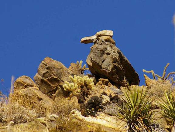
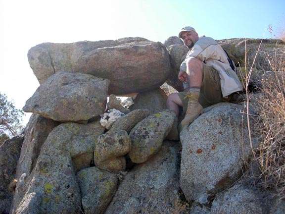
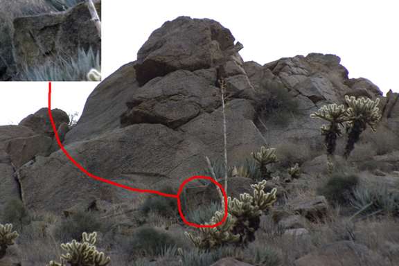
1. On page 43 of this book, Chuck shows an example of a "pointer" rock that is usually accompanied by a white "attention getter" rock sign. These signs are used to point directions onward to the next trail marker. I have a photograph in my collection of just such a sign I found in Boulder Canyon. There is a single rock face about 3 square feet in area that is very white and has a very large color contrast to the rocks around it. Just below this white faced rock is a flat slab rock with a supporting rock under its lifted end -- just like the picture in Chuck's book. The stone points up a tributary canyon off of Boulder Canyon that would lead to Marsh Valley.

2. On page 42 of the book, Chuck describes "Sun Signs" that are made of quartz faced rocks cut into a triangle and positioned such that around high noon they project a triangle light onto a cliff face for notice. Now reference Barry Storm;s book, Thunder God's Gold, on page163 in the Notes of Authenticity - Note 31 which reads:

"31. The only light or refection sign which I have seen so far in the Superstitions was that of a triangle sign reflected onto a cliff face in LaBarge Canyon about three miles above its Boulder Canyon junction. This occurred August 6, 1937, at about 2:00pm and shown for approximately ten minutes".

Note that Chuck says that this sign indicates there is a burial or a hidden entrance hear at hand. If Barry Storm saw this sign at 2:00pm, there is a good posibility it is on the East side of the canyon. Probably a sign worth investigating as the Peraltas stored their gold somewhere prior to loading it for Mexico. There would have to be something of significance for them to go to the labor to create such a sign marker.

As in all things associated with the LDM, one must separate the wheat from the chaff and Chuck is no different. Take what is valuable, discard the remainder and be wiser in the process.

Question: Has anyone been up to the location where Chuck K. claims a Spanish mine to be located on the North end of Bluff Springs Mountain?

Roger

While it is evident that Roger's opinion on the veracity of Kenworthy's work has changed since he made this post in 2002,that is not the reason for my taking note of it.
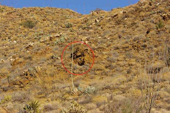
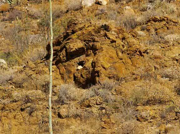
Following are two photos of the kind of markers described:
Image
Image

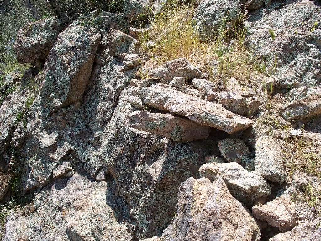
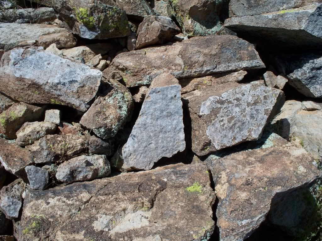
Both were taken last April,within 200 ft. of each other

Regards:SH.
User avatar
Mike McChesney
Expert
Posts: 506
Joined: Thu Apr 20, 2006 1:39 am
Location: Arizona Vagrant

Re: Peralta Stone Maps - Clarence Mitchell Era to the Present

Post by Mike McChesney »

Joe,

It's not "I know a guy who knew a guy." It's "I know a guy that saw it, and that guy's word is beyond reproach." :D

I can't imagine why CK would need to lie about Dr Lyons. You have to remember that CK was a multimillionaire and employed some of the best and most renowned physicists and scientists in the United States (several of the top scientists from SRI [Stanford Research Institute] in his treasure hunting exploits. People like Dr. Lambert Dolphin (father of modern ground penetrating radar), Dr. Bill Beatty (SRI Sr. Mining Engineer), and several others. Read the article at the following link from Dr. Dolphin. The part about CK starts about halfway down in Egypt.

http://ldolphin.org/rpl/ch5.html

CK had some very big name people he worked closely with on a regular basis. Dr. Lyons was no more important than any of the others. I can imagine that if Dr Lyons admitted to working for CK that Fisher might have considered that a conflict of interest and been pissed that Lyons sent that info to CK and didn't give it to him. CK is dead and Lyons still does a lot of business with the Fisher Family. Only a thought.


Nowhere in his books does CK claim that all the information in them is his own proprietary information. EVERY book on signs, symbols, and monuments borrows from ones that came before.

One of your quotes talks about how CK employed an archivist in Seville for 20 years. There were many more than just in Seville. He paid archivists in Rome, Mexico, and several other countries in his quest (no pun intended "Quest" was the name of his TH'ing corporation) for more information.

Okay, I have decided that I will share a bit from one of my old projects. Several of the monuments are described by CK, and his meaning matches exactly with what these mean:

Near the mouth of this canyon is this twenty foot rock. Notice that there is an arrow that points to the top half of a heart.

Image

It is not exactly in CK writings, but I took it to mean that I should follow the arroq (it pointed right down the path). It would eventually lead to something to do with gold that was hidden underground (heart= gold and since only the top half of the heart was there, where the tip of the heart points to is hidden, underground)

Keep following the path for a while and you see this beautiful bird near the top of a 3500 ft ridge.

Image

According to CK, a bird mean that a change in direction is coming soon. The bird was looking down the trail telling me to keep traveling in the same direction, but that a change of direction is coming soon. It turned out to be exactly right.

About a quarter mile further down the trail off to one side, is a box canyon. Smack dab in the middle of this canyon about 100 yards in is an outcropping of dark lava rock. Smack dab in the middle of this outcropping a hole was cut and a big chunk of pegmatited white bull quartz was inserted.

Image

Image

CK calls this an "eye catcher" It is meant to attract your attention to a particular spot. Mother nature did not place that piece of quartz there. Go to that spot and look around, because from there you can see the next marker.

LOW AND BEHOLD! From this position, we can see another matching piece of bull quartz had been placed in a rockfall near the top of a nearby ridge.

Image

Image

Image

Same meaning as before, but this is as far as I'll take you down this trail. There are a couple more, but you get the point. With some monuments and markers you kind of have to shoot from the hip (as with the first arrow monument). If you guess correctly, you will find more monuments/markers/symbols further down the trail. CK's books contained a lot of good information, but not everything.

Best-Mike
User avatar
Mike McChesney
Expert
Posts: 506
Joined: Thu Apr 20, 2006 1:39 am
Location: Arizona Vagrant

Re: Peralta Stone Maps - Clarence Mitchell Era to the Present

Post by Mike McChesney »

Damn, I forgot to resize one of the pics, and left out one.

Here is the resized one. Maybe a mod can delete that huge one and replace it with this:

Image

One I left out was between the Arrow Boulder and the Bird. It is a nice number "7" that is right near a nice protected camp site.

Image

Best-Mike
User avatar
Mike McChesney
Expert
Posts: 506
Joined: Thu Apr 20, 2006 1:39 am
Location: Arizona Vagrant

Re: Peralta Stone Maps - Clarence Mitchell Era to the Present

Post by Mike McChesney »

Did it again. It's hell getting old! HAHAHAHAHA

Image

Mike
User avatar
Mike McChesney
Expert
Posts: 506
Joined: Thu Apr 20, 2006 1:39 am
Location: Arizona Vagrant

Re: Peralta Stone Maps - Clarence Mitchell Era to the Present

Post by Mike McChesney »

Joe,

It's not "I know a guy who knew a guy." It's "I know a guy that saw it, and that guy's word is beyond reproach." :D

I can't imagine why CK would need to lie about Dr Lyons. You have to remember that CK was a multimillionaire and employed some of the best and most renowned physicists and scientists in the United States (several of the top scientists from SRI [Stanford Research Institute] in his treasure hunting exploits. People like Dr. Lambert Dolphin (father of modern ground penetrating radar), Dr. Bill Beatty (SRI Sr. Mining Engineer), and several others. Read the article at the following link from Dr. Dolphin. The part about CK starts about halfway down in Egypt.

http://ldolphin.org/rpl/ch5.html

CK had some very big name people he worked closely with on a regular basis. Dr. Lyons was no more important than any of the others. I can imagine that if Dr Lyons admitted to working for CK that Fisher might have considered that a conflict of interest and been pissed that Lyons sent that info to CK and didn't give it to him. CK is dead and Lyons still does a lot of business with the Fisher Family. Only a thought.


Nowhere in his books does CK claim that all the information in them is his own proprietary information. EVERY book on signs, symbols, and monuments borrows from ones that came before.

One of your quotes talks about how CK employed an archivist in Seville for 20 years. There were many more than just in Seville. He paid archivists in Rome, Mexico, and several other countries in his quest (no pun intended "Quest" was the name of his TH'ing corporation) for more information.

Okay, I have decided that I will share a bit from one of my old projects. Several of the monuments are described by CK, and his meaning matches exactly with what these mean:

Near the mouth of this canyon is this twenty foot rock. Notice that there is an arrow that points to the top half of a heart.

Image

It is not exactly in CK writings, but I took it to mean that I should follow the arroq (it pointed right down the path). It would eventually lead to something to do with gold that was hidden underground (heart= gold and since only the top half of the heart was there, where the tip of the heart points to is hidden, underground).

About a mile down this trail, high up on the ridge is this rock formation:

Image

Just around the back of this formation is a nice camp site. Well protected from the wind. So the number "7" (when carved on a rock) mean that a protected camp site is nearby.

Keep following the path for a while and you see this beautiful bird near the top of a 3500 ft ridge.

Image

According to CK, a bird mean that a change in direction is coming soon. The bird was looking down the trail telling me to keep traveling in the same direction, but that a change of direction is coming soon. It turned out to be exactly right.

About a quarter mile further down the trail off to one side, is a box canyon. Smack dab in the middle of this canyon about 100 yards in is an outcropping of dark lava rock. Smack dab in the middle of this outcropping a hole was cut and a big chunk of pegmatited white bull quartz was inserted.

Image

Image

CK calls this an "eye catcher" It is meant to attract your attention to a particular spot. Mother nature did not place that piece of quartz there. Go to that spot and look around, because from there you can see the next marker.

LOW AND BEHOLD! From this position, we can see another matching piece of bull quartz had been placed in a rockfall near the top of a nearby ridge.

Image

Image

Image

Same meaning as before, but this is as far as I'll take you down this trail. There are a couple more, but you get the point. With some monuments and markers you kind of have to shoot from the hip (as with the first arrow monument). If you guess correctly, you will find more monuments/markers/symbols further down the trail. CK's books contained a lot of good information, but not everything.

Best-Mike
Somehiker
Part Timer
Posts: 440
Joined: Wed May 03, 2006 6:00 pm

Re: Peralta Stone Maps - Clarence Mitchell Era to the Present

Post by Somehiker »

Another photo shot last April,about half way between the Priest and Horse,and next to an old trail.A single piece of white quartz from amongst the rocks,probably a monument, at my feet.I did a bit of looking around,but could not find any other white quartz in the vicinity.

Regards:SH
Attachments
quartz at old marker cairn.jpg
quartz at old marker cairn.jpg (213.5 KiB) Viewed 20803 times
Elwood
Posts: 2
Joined: Tue Nov 13, 2007 9:59 pm

Re: Peralta Stone Maps - Clarence Mitchell Era to the Present

Post by Elwood »

Hi Mike,

If you had not noticed I wanted to bring this item to your attention. PLease note that in the photograph depicting yourself you will find a desert tortois's head just under the white rock. You can also clearly see his right leg in the rock formation. He seems to have his eyes fixed on something in front of you. Look closely at the four brown stains found on the rock under your left foot. Could be a distance marker; four veras, four ? I can't see ahead of you. Look for an obvious witness mark within a circular area circling your monument.

Elwood Blue
Attachments
Turtlehead [Desktop Resolution].jpg
Turtlehead [Desktop Resolution].jpg (163.76 KiB) Viewed 20732 times
Seeking knowledge and Wisdom
User avatar
Mike McChesney
Expert
Posts: 506
Joined: Thu Apr 20, 2006 1:39 am
Location: Arizona Vagrant

Re: Peralta Stone Maps - Clarence Mitchell Era to the Present

Post by Mike McChesney »

Elwood,

Thanks, but that isn't exactly what that is. :wink: There are no turtles in this trail of monuments. I have chased it down from Alpha to Omega.

Best-Mike
Elwood
Posts: 2
Joined: Tue Nov 13, 2007 9:59 pm

Re: Peralta Stone Maps - Clarence Mitchell Era to the Present

Post by Elwood »

Mike McChesney wrote:Elwood,

Thanks, but that isn't exactly what that is. :wink: There are no turtles in this trail of monuments. I have chased it down from Alpha to Omega.

Best-Mike
Hi Mike,

What did you find at the end of the trail if I may ask? So am I to assume that you ended up where you started? Just curious and thanks to you for any forthcoming info.

Elwood
Seeking knowledge and Wisdom
User avatar
Mike McChesney
Expert
Posts: 506
Joined: Thu Apr 20, 2006 1:39 am
Location: Arizona Vagrant

Re: Peralta Stone Maps - Clarence Mitchell Era to the Present

Post by Mike McChesney »

Elwood wrote:
Mike McChesney wrote:Elwood,

Thanks, but that isn't exactly what that is. :wink: There are no turtles in this trail of monuments. I have chased it down from Alpha to Omega.

Best-Mike
Hi Mike,

What did you find at the end of the trail if I may ask? So am I to assume that you ended up where you started? Just curious and thanks to you for any forthcoming info.

Elwood
Sorry E,

Not sharing the last couple of monuments and anything that may or may not have been at the end.

I only included a good portion of this monumented trail to show that Chuck Kenworthy wasn't making up a bunch of BS to fill his books.

Best-Mike
Joe Ribaudo
Expert
Posts: 5453
Joined: Tue Sep 17, 2002 10:36 pm

Re: Peralta Stone Maps - Clarence Mitchell Era to the Present

Post by Joe Ribaudo »

Elwood and Mike,

Just curious......Did either of you guys notice the phocid looking up at the white rock?

What do you suppose that means. Actually, I think that's a much better depiction than the turtle.

Take care,

Joe
User avatar
Mike McChesney
Expert
Posts: 506
Joined: Thu Apr 20, 2006 1:39 am
Location: Arizona Vagrant

Re: Peralta Stone Maps - Clarence Mitchell Era to the Present

Post by Mike McChesney »

Joe,

HAHAHA I can do you better than that! Look for the Tapir whose snout ends at the piece of quartz.

Best-Mike
User avatar
Mike McChesney
Expert
Posts: 506
Joined: Thu Apr 20, 2006 1:39 am
Location: Arizona Vagrant

Re: Peralta Stone Maps - Clarence Mitchell Era to the Present

Post by Mike McChesney »

Here's a hint
Attachments
tapir1.gif
tapir1.gif (251.04 KiB) Viewed 20830 times
NeedleMan
Greenhorn
Posts: 46
Joined: Wed Sep 19, 2007 11:49 am

Re: Peralta Stone Maps - Clarence Mitchell Era to the Present

Post by NeedleMan »

Sorry Dudes your way off on your assessment of CK's work.

Followed many quartz eye catchers and many, many "7"s along with triangles, defused light reflectors and the only state you'll end up in is one of confusion!

Ck's work leaves room to ponder but most of it is total BS even TK will tell you that and he's the one that wrote the book not CK!

Don't believe it yourself or you can get in trouble digging false blind holes in the Sups.

Many have already.

Show us the Gold and your verification from Scott and people might believe you have something there.

Otherwise it's a good story and like so many it lacks true grit.

Needleman
User avatar
Mike McChesney
Expert
Posts: 506
Joined: Thu Apr 20, 2006 1:39 am
Location: Arizona Vagrant

Re: Peralta Stone Maps - Clarence Mitchell Era to the Present

Post by Mike McChesney »

So,

Your saying that you know Chuck's Son? What is your name? I'll ask. The people that Chuck N talks to about Treasure Hunting are few and far between.

I guess that you can back up what you say about CK? Maybe?

Many of the sharpest minds in the world knew the man, saw some of what he found, and believed in his theories. I guess you are smarter than them.

Maybe you should Google the name Dr. Lambert Dolphin. Lambert was quite close to Chuck from the early 1970s until his death. Lambert was the Head Physicist for SRI (Stanford Research Institute). He is also known as the Father of Modern Ground Penetrating Radar.

If you want to read something about the man and his relationship with CK:

http://ldolphin.org/rpl/ch5.html

Before making snide remarks about someone you never knew, maybe you can provide some supporting evidence to back up your claims?

Best-Mike
Post Reply