Wayne,
I agree with you on the Jesuit history thingie. I am easily led down that road because of my research into that history, and personal contacts with some well known Jesluits.
Azmula,
"If you read all of the emails you would interpret the facts as only the cream colored stone being seen carved by Travis. Travis liked using images like the horse and priest which have little to do with where the stone maps lead (personal opinion). Check the chimney carving photos as examples. Difference in stone material of H/P and red stones, carving techniques of H/P and red stones, and differences in content.
My interpretation of the facts have not changed from original concepts. I have found additional information which confirms my interpretation of the facts."
Actually, your original concepts have changed about the Horse/Priest Stone. It's good to see that you were open to the new facts that have been exposed recently. I have always dismissed the Horse/Priest Stone as a fake.
On the other hand, I have never done the kind of extensive personal research into the Stone Maps that you, and others have done. Despite what you may think, I have always admired your work and have said so on every forum I have ever been on, as well as personal conversations with many of my Dutch hunting friends.
I would like to have a civil conversation with you, but understand feelings about me.
Good luck,
Joe
THE GENUINE STONE MAPS
Re: THE GENUINE STONE MAPS
Azmula:
I have some observations to make,but will need to quote portions of several e-mails used in your article.Do you mind?
Regards:Wayne
I have some observations to make,but will need to quote portions of several e-mails used in your article.Do you mind?
Regards:Wayne
Re: THE GENUINE STONE MAPS
SH,
I don't mind your quotes if you do not mind my non-responses where applicable...
Take care, azmula
I don't mind your quotes if you do not mind my non-responses where applicable...
Take care, azmula
Re: THE GENUINE STONE MAPS
Joe and Azmula:
I have copied and pasted those passages from the e-mails which,to me at least,indicate that the relatives you corresponded with remember Travis working on more than one stone map.That they are talking about at least the three map stones seems obvious.
"As for Travis and the "papers" he worked
from, they were just pieces of paper (more than
one) with drawings on them, to your Grandma. He
folded them up between uses and carried them in
his pocket, taking them out to make the etching on
the stones. In and of themselves they didn't appear
to have much value, other than the source of the
pictures he copied onto the stones. The stones
themselves were never hidden, whether or not he
was working on them."
Another about "maps"...
"By the way, Travis' widow "AIleen" sold those
Stone Maps to a sucker after Uncle Travis died. She
was warned by everyone in the family she was
going to get in trouble for representing them as
"real maps" and that no-one was ABOUT to stick
their neck out to support her claim of something
"found" in the desert, but she sold them anyway,
for (I think) 200 or 300 dollars. It should also be
noted that Uncle Travis NEVER used those "maps"
to search for the Lost Dutchman, and neither did
AIleen, who also watched him make them in your
Grandma's front yard."
And another reference to "maps".
"The "stone maps" supposedly "found" in
Arizona were, in fact, created in your Grandma
Tumlinson's yard in Cuero by her brother, your
Great UncleTravis Tumlinson. (deleted by author)
herself watched him make them, copying symbols
from a piece of paper of unknown origin. Only the
"stones" came from Arizona and he picked them up
off the roadside there on a return trip from Oregon."
Another statement of great significance IMO,is this ...
"It should also be
noted that Uncle Travis NEVER used those "maps"
to search for the Lost Dutchman, and neither did
AIleen, who also watched him make them in your
Grandma's front yard. After he made them they
never left Cuero (or your Grandma's house) until
Alleen sold them to,"
Which means of course,if all true,that no other person had a hand in the making of the stone maps.
That the stone maps were not made with the aid of a topo map of any vintage or area.
That no one in Hood River ever saw the stones.
That no DutchHunter saw the stone maps before Clarence Mitchell purchased them from Alleen Tumlinson.
Can you not see the conflicting nature of all of this testimony,relative to what has been collected and reviewed previously ?
Regards:Wayne
Re: THE GENUINE STONE MAPS
There are other details of the family account which do,or should prompt further discussion.
For example:
Azmula,Gary,Mike:
Given the report done by Desert Archaeology Inc.,which clearly stated the stones had been carved using modern power tools (drill,dremel,and sanding machinery).
And since all of you have communicated with members of the Tumlinson family.
Did any of the family members mention what kind of tools Travis was seen to be using while carving the stones ? Have any of you asked ?
Joe:
Two key elements revealed within the e-mails are:
That Travis,at no time tried to hide the fact that it was he who was carving the stones.
In fact he did so out front of the grandmother's house,in full view of family and neighbours.,I presume,as well as any passerby who might question what he was doing.Especially with the attention-getting noise created by power tools.
How does this fit the "did it for money theory",which you and others have espoused.
And:
It is claimed by family in these e-mails,the Stone Maps (plural) remained at the grandmother's residence until they were sold to Clarence Mitchell,whose knowledge of the maps is explained.Further,no mention is made of Aylor,DeGrazia,Ward,or any of the other DHr's
being involved or having even visited the grandmother's residence.
Can you still believe any one of them was somehow involved ?
Regards:Wayne
Re: THE GENUINE STONE MAPS
I have copied and pasted those passages from the e-mails which, to me at least, indicate that the relatives you corresponded with remember Travis working on more than one stone map. That they are talking about at least the three map stones seems obvious.
I interpreted “maps” in the emails as all three stones both sides initially until I asked one question, “Did you see Travis carve the cream maps or the red maps or all of the maps?” All that anyone could remember was him carving the cream colored maps.
"As for Travis and the "papers" he worked
from, they were just pieces of paper (more than
one) with drawings on them, to your Grandma. He
folded them up between uses and carried them in
his pocket, taking them out to make the etching on
the stones. In and of themselves they didn't appear
to have much value, other than the source of the
pictures he copied onto the stones. The stones
themselves were never hidden, whether or not he
was working on them."
Another about "maps"...
"By the way, Travis' widow "AIleen" sold those
Stone Maps to a sucker after Uncle Travis died. She
was warned by everyone in the family she was
going to get in trouble for representing them as
"real maps" and that no-one was ABOUT to stick
their neck out to support her claim of something
"found" in the desert, but she sold them anyway,
for (I think) 200 or 300 dollars. It should also be
noted that Uncle Travis NEVER used those "maps"
to search for the Lost Dutchman, and neither did
AIleen, who also watched him make them in your
Grandma's front yard."
I never said that I accepted every comment as the gospel, after all these are 60 year old memories. Who is to say that even a sucker from Phoenix would buy stone maps he had never seen? Travis did not tell everyone everything he knew or did.
And another reference to "maps".
"The "stone maps" supposedly "found" in
Arizona were, in fact, created in your Grandma
Tumlinson's yard in Cuero by her brother, your
Great UncleTravis Tumlinson. (deleted by author)
herself watched him make them, copying symbols
from a piece of paper of unknown origin. Only the
"stones" came from Arizona and he picked them up
off the roadside there on a return trip from Oregon."
Maps can mean one map on each side of the stones.
Another statement of great significance IMO, is this ...
"It should also be
noted that Uncle Travis NEVER used those "maps"
to search for the Lost Dutchman, and neither did
AIleen, who also watched him make them in your
Grandma's front yard. After he made them they
never left Cuero (or your Grandma's house) until
Alleen sold them to,"
I don’t believe that Travis knew enough about the maps or the Superstitions to go in prospecting.
Which means of course, if all true, that no other person had a hand in the making of the stone maps.
That the stone maps were not made with the aid of a topo map of any vintage or area.
That no one in Hood River ever saw the stones.
That no Dutch Hunter saw the stone maps before Clarence Mitchell purchased them from Alleen Tumlinson.
Can you not see the conflicting nature of all of this testimony, relative to what has been collected and reviewed previously ?
I have to admit that I would believe my Tumlinson family sources before I would believe the comments from individuals who were not necessarily cognizant of all issues.
Take care,
azmula
Re: THE GENUINE STONE MAPS
Azmula:
The colors of the "original" or "true" maps has been a matter previously discussed.
As has the existence,it seems,of several sets of copies which vary in both size and colour.
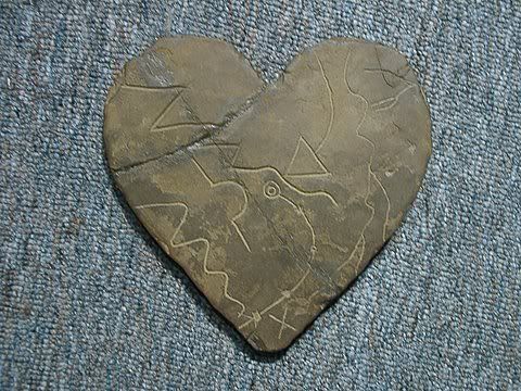
Depending on the lighting source,as well as which set of maps various people have seen,there seems to be some confusion as to what the true colour if each of the stones,including the heart,really is.
The stones on display at the SMHS Museum,said to be the originals,to my eyes are:
H/P Stone....light grey (whitish where the stone has been chipped)with reddish rust staining and brown staining in a few spots.
Trail Stones....light brown/buff with only a bit of a trend toward the red.
Almost too consistent in colour to be natural stone,IMO.
Heart Stone....dark brown/trending to deep red or maroon.
colour varies within layers as well.
They were however,in the display case and under fluorescent lighting when I viewed and photographed them,but the photos which Mike shot outdoors look much the same to me.
Has anyone e-mailed the family photos of the "real" stone maps,for commentary ?
Just to be sure.
Mike's outdoor photos would probably be the best
Regards:Wayne
The colors of the "original" or "true" maps has been a matter previously discussed.
As has the existence,it seems,of several sets of copies which vary in both size and colour.
Depending on the lighting source,as well as which set of maps various people have seen,there seems to be some confusion as to what the true colour if each of the stones,including the heart,really is.
The stones on display at the SMHS Museum,said to be the originals,to my eyes are:
H/P Stone....light grey (whitish where the stone has been chipped)with reddish rust staining and brown staining in a few spots.
Trail Stones....light brown/buff with only a bit of a trend toward the red.
Almost too consistent in colour to be natural stone,IMO.
Heart Stone....dark brown/trending to deep red or maroon.
colour varies within layers as well.
They were however,in the display case and under fluorescent lighting when I viewed and photographed them,but the photos which Mike shot outdoors look much the same to me.
Has anyone e-mailed the family photos of the "real" stone maps,for commentary ?
Just to be sure.
Mike's outdoor photos would probably be the best
Regards:Wayne
-
Joe Ribaudo
- Expert
- Posts: 5453
- Joined: Tue Sep 17, 2002 10:36 pm
Re: THE GENUINE STONE MAPS
Wayne,
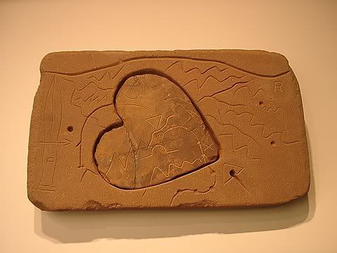
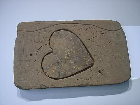
Here are some different angles of the heart:
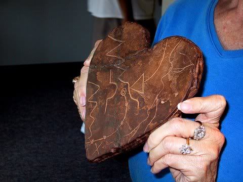
These under different lightning do not look like the same stone that Carolyn is holding:
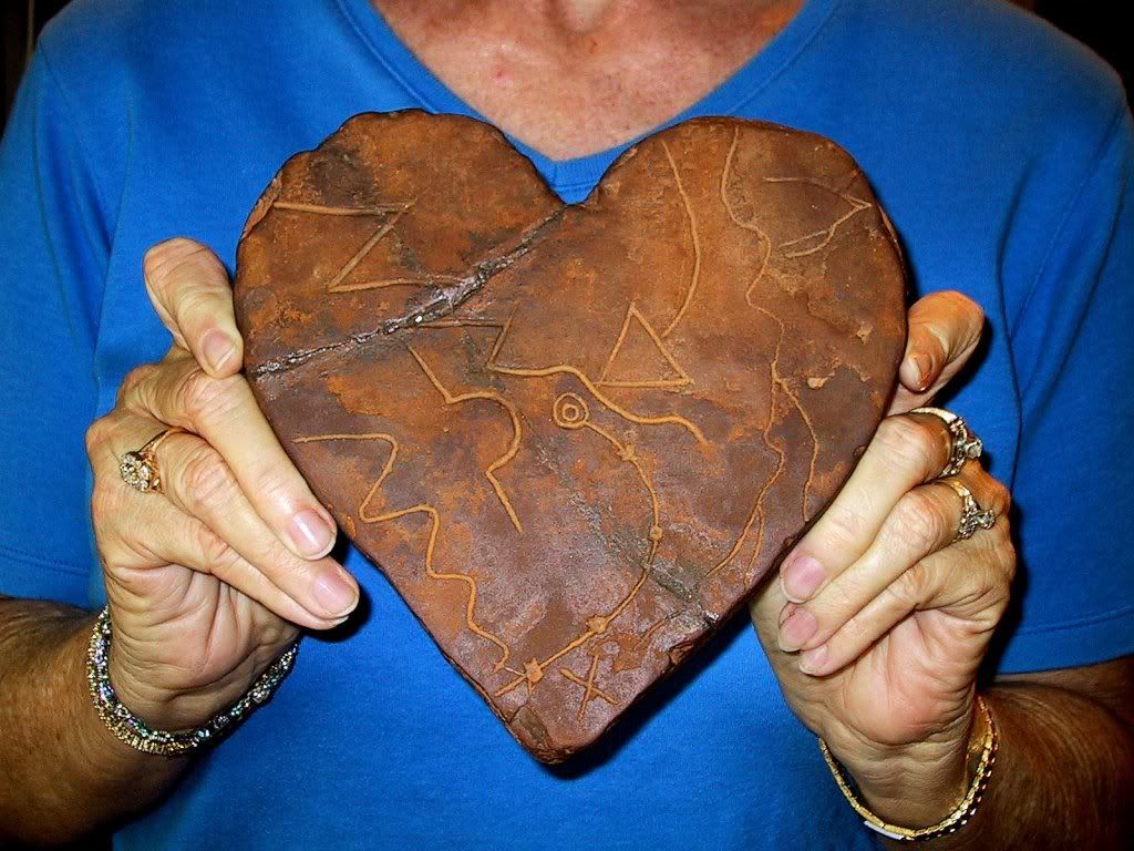
I believe Carolyn is holding the original heart.
Take care,
Joe
Here are some different angles of the heart:
These under different lightning do not look like the same stone that Carolyn is holding:
I believe Carolyn is holding the original heart.
Take care,
Joe
Re: THE GENUINE STONE MAPS
SH,
I agree with you about the effects of light sources and background on photos. The photos in my article were taken outside of the Museum in normal sun light with a film camera and later digitized (no photo shopping), while the backgrounds were neutral.
The best photos that I have seen were taken by Jack San Felice out of doors in sun light with green grass as a background.
The Tumlinson family critiqued the draft of the article with photos and have personal copies of the Journal with article Part 1.
Best, azmula
-
Joe Ribaudo
- Expert
- Posts: 5453
- Joined: Tue Sep 17, 2002 10:36 pm
Re: THE GENUINE STONE MAPS
Wayne and Azmula,
I'm no expert, but I believe the best color pictures (most accurate) are taken inside under studio lighting.
The best pictures I have were taken in the Mining and Mineral Museum with professional lighting and with a professional grade camera by Steve Decker. Steve took the pictures using different colored lighting, as well as no artificial color, to bring out more detail. They can be blown up to around 400 % with little distortion.
Here are a few samples:
I believe something is lost when you transfer away from the original CD, but you can blow up what's posted here to get really close detail. You can see that there seems to be a lot of difference, color-wise between Steve's pictures and the one with Carolyn holding the heart. I believe that picture is the most accurate for color.
Take care,
Joe
-
Joe Ribaudo
- Expert
- Posts: 5453
- Joined: Tue Sep 17, 2002 10:36 pm
Re: THE GENUINE STONE MAPS
Azmula and Wayne,
"I don’t believe that Travis knew enough about the maps or the Superstitions to go in prospecting.
Which means of course, if all true, that no other person had a hand in the making of the stone maps.
That the stone maps were not made with the aid of a topo map of any vintage or area.
That no one in Hood River ever saw the stones.
That no Dutch Hunter saw the stone maps before Clarence Mitchell purchased them from Alleen Tumlinson."
I know neither of you are buying my conclusions of the topography of the Stone Maps, but there are too many exact matches for them to have been done without information from someone very familiar with the Supes'.
In my opinion, the Stone Maps were not made from a topo', nor from a plane. They required high vantige points in the mountains, as well as someone who was very, very familiar with the terrain. Just one examplel of that, is the trail that breaks off to the southeast around the two small hills on the north end of Black Top. That trail is not on any map, that I know of, other than the Stone Maps. The only people who know or knew about it were old time Dutch Hunters.
A known, and previously mapped trail, is the Military Trail the climbs out of West Boulder, east to a saddle before dropping down into Little Boulder and directly into the heart. The Stone Maps are extreamly accurate with only a very few anomolies, I assume because a higher vantage point was not available.
Way too many dead on landmarks to be attributed to chance or blind luck. I don't really mind the critiques or abuse over my map, as that's just part of the game when you put your conclusions out there for public consumption.
Next Rendezvous I will happy to draw the Stone Maps on a clean topo' for you Wayne.
Take care,
Joe
Re: THE GENUINE STONE MAPS
Joe:
Photos shot under studio lighting,while they may give good results,are not what I had in mind.
Photos taken under lighting such as that which would have existed while Travis was witnessed carving the stones, is what I was thinking of.As your studio photos demonstrate,different lighting causes perceived colour change to both subject and background.Lens filters will do the same,with polarizing filters even reducing or eliminating the sheen of the heart stone.
Azmula:
Can you post the photo set by which the family members identified the stones.
I would like to see how they compare with those I shot indoors.
Please humour me as to when were they taken,and where ?..as well,if you can.
Regards:Wayne
Re: THE GENUINE STONE MAPS
SH,
The photos they saw was the set used in the SMHS Journal article. I took these photos at the museum, in the daylight, outside, June 27,2007.
I believe that answers your question.
azmula
The photos they saw was the set used in the SMHS Journal article. I took these photos at the museum, in the daylight, outside, June 27,2007.
I believe that answers your question.
azmula
Re: THE GENUINE STONE MAPS
Wayne,
I aplogize for running so far behind the curve here!
In your posts of March 1st you have done some excellent analysis and have offered some thoughtful questions. You have broken down the published e-mails, which in reality are what is really new in the article. I have been on a different research track and your detail analysis was very thought provoking.
Each question deserves its own discussion and the rest of us may be a bit overwhelmed with your sheer number of thoughts.
Your first comment involved the family indicating that Travis carved the “MAPS” as opposed to the “SINGLE” horse/priest stone that Azmula is proposing.
My take on the three e-mails that Azmula shared was that there was one “uncle” supplying almost all of the information involving Travis carving the “Maps”? For clarity of discussion ,so that there is no confusion between this Uncle and Uncle Billy Lowain Tumlinson, I will simply refer to him as “Uncle George” for want of a better term.
I have referred to “Uncle” Billy Tumlinson in the other thread.
Azmula’s respose to your analysis of the use of the term“MAPS”
IF, I’m reading things correctly and the statement is correct, it is a major addition beyond what shows up in the three e-mails. I will offer further thoughts unless I’m reading something in that isn’t there.
If Travis carved the stone around 1949, when would these eye-witnesses have been born for them to recall something like the color of the stone that Travis was using to carve the stones? Put youself in young person’s shoes who is relating a story that happened over 60 years ago. Maybe 1949 is all wrong?
Thanks,
Garry
I aplogize for running so far behind the curve here!
In your posts of March 1st you have done some excellent analysis and have offered some thoughtful questions. You have broken down the published e-mails, which in reality are what is really new in the article. I have been on a different research track and your detail analysis was very thought provoking.
Each question deserves its own discussion and the rest of us may be a bit overwhelmed with your sheer number of thoughts.
Your first comment involved the family indicating that Travis carved the “MAPS” as opposed to the “SINGLE” horse/priest stone that Azmula is proposing.
My take on the three e-mails that Azmula shared was that there was one “uncle” supplying almost all of the information involving Travis carving the “Maps”? For clarity of discussion ,so that there is no confusion between this Uncle and Uncle Billy Lowain Tumlinson, I will simply refer to him as “Uncle George” for want of a better term.
I have referred to “Uncle” Billy Tumlinson in the other thread.
Azmula’s respose to your analysis of the use of the term“MAPS”
From Azmula’s response, it sounds to me like we are dealing with at least one eye-witness and the implication for me is that there could be more that one eye-witness? I don’t believe I’m misinterpreting this, as Azmula’s question was “Did you see Travis……” but if I am, please help me out.I interpreted “maps” in the emails as all three stones both sides initially until I asked one question, “Did you see Travis carve the cream maps or the red maps or all of the maps?” All that anyone could remember was him carving the cream colored maps.
IF, I’m reading things correctly and the statement is correct, it is a major addition beyond what shows up in the three e-mails. I will offer further thoughts unless I’m reading something in that isn’t there.
If Travis carved the stone around 1949, when would these eye-witnesses have been born for them to recall something like the color of the stone that Travis was using to carve the stones? Put youself in young person’s shoes who is relating a story that happened over 60 years ago. Maybe 1949 is all wrong?
Thanks,
Garry
-
Joe Ribaudo
- Expert
- Posts: 5453
- Joined: Tue Sep 17, 2002 10:36 pm
Re: THE GENUINE STONE MAPS
Garry,
That was what I was thinking as well. I can't remember what I had for breakfast yesterday, let alone color nuances from 60-years ago.
Answers never come easy with the Stone Maps.
I'm just along for the ride here. The three of you are doing some great research......still. Thanks for sharing.
Take care,
Joe
Re: THE GENUINE STONE MAPS
My questions regarding the location and date of the photos published in the article,and forwarded to the family were intended to help me determine which set of maps appear in your photos.
The first paragraph in the article informs the reader of the arrival and unveiling of what the SMHS museum has claimed are the "original Stone Maps".Up until that date (June 25,2009),the stones on display were a set of copies.
"On June 25, 2009, a loan agreement was
reached by which the Stone Maps were moved
from the Arizona Mining and Minerals Museum to
the Superstition Mountain Museum to obtain better
exposure of the maps to the interested public."
The previous custodians of these "original Stone Maps" had been the Arizona Mining & Mineral Museum,first at the facility in Mesa and later at the location in Phoenix,where they were kept secure in a vault.The general public were however,able to view a set of copies fabricated for museum display and travelling road shows.In this quote,Roger describes the circumstances of his own viewing of the originals.
"Roger
Post subject: Stone Maps at Mesa Museum
PostPosted: Fri Mar 17, 2006 10:02 am
Offline
Part Timer
Joined: Wed Dec 31, 1969 7:00 pm
Posts: 329
Bushrat,
I also saw the Stone Maps on display in the Mesa Museum in the early 1990's that were in a glass display case. After talking with the Museum staff, I learned that the ones on display were replica's and the real stones were kept in a locked vault in the back of the Museum. I inquired if I could see the real ones and they said yes, but I would have to pay $15/hr for an observer (read college student) to watch me all the time. I did this and took about 2 hrs looking at the stones in the back room on a bench. I made several etchings or rubbings of areas of the stones that I wanted to have more detail on. I also found in this examination that the words "Santa Fe" were scribed into the left hand side (not top, but the edge) of the Horse Stone and that the two "river" lines actually ran around the edge of the stone onto the side. "Santa Fe" was written between these two lines on the left side of the stone. It is obvious that if the two rivers on the Horse Stone are related to the Superstitions, then Santa Fe has to be on the right of these two rivers - not the left. However, since the word lays between the two rivers and the word Rio is shown, one has to reverse the location of "Santa Fe" in mirror fashion which puts it on the correct side.
Had posted this info back a while, but thought it might be of interest to any newcomers.
Roger "
The balance of the first paragraph,as well as the second (describing the maps now on display) gives what I take to be Azmula's first time examination of these "original Stone Maps".
Therefore,IMO,it raises the question as to which set were taken outdoors to be photographed on June 27,2007.As we know,and have discussed at length,there are many sets of copies in both museums as well as in private collections.There is also a wide range of colours apparent in these "replicas".
Regards:SH.
Re: THE GENUINE STONE MAPS
One last quote from the e-mails,about the number of "maps".
In order to carve two maps on opposite sides of a single stone,Travis would have only required one stone.
In order to carve all of the maps,the four which make up the entire set of "Stone Maps",Travis would have needed more than one stone,since they are comprised of differing types of stone.
One witness describes Travis' acquisition of raw material. The word "stones",once again plural,is used.
"The "stone maps" supposedly "found" in
Arizona were, in fact, created in your Grandma
Tumlinson's yard in Cuero by her brother, your
Great UncleTravis Tumlinson. (deleted by author)
herself watched him make them, copying symbols
from a piece of paper of unknown origin. Only the
"stones" came from Arizona and he picked them up
off the roadside there on a return trip from Oregon."
Regards:SH.
-
Mike McChesney

- Expert
- Posts: 506
- Joined: Thu Apr 20, 2006 1:39 am
- Location: Arizona Vagrant
Re: THE GENUINE STONE MAPS
.No matter what the relatives say, Azmula's Theory (from his article), still seems to hold water for me.
Here's why (Letter from Mel Brower to Richard Peck):
The first quote is in answer to the family email that stated unequivocally that Travis had never searched in the mountains to solve the maps.
Mike
Here's why (Letter from Mel Brower to Richard Peck):
The first quote is in answer to the family email that stated unequivocally that Travis had never searched in the mountains to solve the maps.
The next quote may answer the question about the H/P Stone.I was then told by Bob that Travis had started a manuscript a few years before his death and had almost finished it at the time of his passing............~~~ ............. The manuscript had and did reveal the place the maps were found, much on the search and the experiences of the search.
(MY THOUGHT) Maybe Travis was not a dishonest person and didn't show his friend the one he made, or maybe he hadn't the H/P Stone yet.Bob stated that he and Travis had planned a two week trip into the Superstition Mts, but that trip was cut short by the death of Travis. I asked him if he had seen all the stones and he stated he had. I then ask (sic) him how many Travis had found and he said three stones counting the heart stone. I then suspected that Travis had not, even to his closest friends, revealed all the maps.
I don't remember exactly which letter it was in, but I am always nagged by that visual of Travis sitting with his close friend. Sticking his finger in that big hole and saying "If I could only figure out where this is, I'd be a millionaire." To me, that in no way sounds like someone who had made that stone.To confirm this, I ask him if he remembered the horse carved on one side of the maps. He seemed somewhat shocked and said he had never seen any maps with a horse carved on it.
Mike
Re: THE GENUINE STONE MAPS
Mike,
Thanks for laying out your argument and including sources for your reasoning. Travis carving the H/P stone addresses a lot of other questions. The misspelled Spanish words, the block lettering, the similarity of other Travis Stone carvings, etc. The trail maps do not have these types of features and an argument can be made that there is nothing, at least content wise, that point to Travis.
I think you may be saying that you believe Travis found the trail maps as advertised? Exactly how do you believe he found the trail maps? According to Mitchell’s story and also in Travis’s manuscript the H/P stone was the one stumbled over and it was a year later, using clues from the H/P stone, that he dug up the trail maps. Are you in agreement with this sequence?
There are several stories of how he found the stones and this does little in my eyes to provide a lot of credibility for the stumbling over the stones theory. The Prince Albert can and the overheated car, searching for arrowheads, trying to catch a glimpse of Weaver’s Needle, relieving himself, etc.)
I have seen even treasure hunters question whether Travis simply stumbled over the stones near Queen Creek. My take is that Azmula may have a different view of how the trail maps came into the possession of Travis?
I also sense you may be suggesting that the H/P stone was carved by Travis much later than 1949? Bob Schultz??? was not aware of the H/P stone?
Have you fleshed out your theory beyond what I have repeated?
Thanks,
Garry
-
Mike McChesney
- Expert
- Posts: 506
- Joined: Thu Apr 20, 2006 1:39 am
- Location: Arizona Vagrant
Re: THE GENUINE STONE MAPS
Hey Garry,
No, I haven't fleshed out the whole thing yet. They could have been found at Queen Creek, or they could have been pulled from the floor of the Arizpe Mission.
Honestly, to me, if the maps are of Jesuit origin, then the Arizpe Mission origin makes the most sense. I can't REALLY say, though, without some kind of historical document to back up one side or the other.
Most all of my theories of this subject are based on reported human interactions with the stone maps. I know what people in different situations do and don't do. How they act and don't act. None of Travis' actions in the entire time he had possession of the stones, were indicative of a man who was in any way perpetrating a hoax. The mere fact that he MOSTLY kept the stones existence a secret for the entire twelve years of his ownership speaks volumes to me.
Best - Mike
Re: THE GENUINE STONE MAPS
Two of the three e-mails published within Azmula's article reveal both past and current public position of Tumlinson family members relating to the history of Travis' grandfather,John J. "PegLeg" Tumlinson .
In the second of the three,dated July 5,2009 ,the respondent (quoting the words of his uncle) relates how family members of previous generations were counselled to deny any knowledge of a "PegLeg" Tumlinson.
Later,in his own words,he further emphatically states that Travis and
his father were the treasure hunters,not Travis' grandfather PegLeg.
Given the publication of Coronado's Children,by Frank Dobie in 1930
(1 1/2 years into the great depression) and Dobie's tales of PegLeg's aquisition of treasure documents and search for at least one treasure,I could understand such denials by the Tumlinsons.Deceptive?..Yes,but with so many people,out of work and money and wandering the country in search of an income,such notoriety would have meant constant disruption in their lives at the very least.So it's understandable why the family would adopt such a policy.
An exerpt of Coronado's Children,the PegLeg story also was published in the Laredo Times on Oct. 29,1931(http://newspaperarchive.com/laredo-time ... -29/page-6).This may have brought additional unwanted attention from outsiders.
The third e-mail,also quotes an "uncle" who remembers PegLeg as having some "strange and wild friends" but undeserving himself of any reputation as a treasure seeker or even as a traveller,having "spent his entire life
in and around Dewitt County."
Further,he goes on to say that although there are "legends" about the Tumlinson family in Texas,that most are just "campfire tales".
The growth of the internet,(http://www.internetworldstats.com/top20.htm),with 78.2% of the US poulation online (245 million),has likely also increased the level of interest in both the Stone Maps and the Tumlinson family.Many members of the family I would think,are connected as well.A browser search of "tumlinson" alone gives a first page link to the "Tumlinson Family Genealogy Forum" of ancestry.com.(http://genforum.genealogy.com/tumlinson/).Two posts very near the top of the page should be of interest to both the Tumlinson family and ourselves.(http://genforum.genealogy.com/tumlinson ... es/86.html)
And the second link:
(http://genforum.genealogy.com/tumlinson ... es/85.html)
because it further links to this:
(http://www.waymarking.com/waymarks/WM3W29).
The first message for which I gave the link above,IMO,would be more than enough to prompt any Tumlinson,curious about their ancestry,to search online for further information.A search for "PegLeg Tumlinson" in Google,for just one example,results in a first page with 10 results.
Of those ten,six are links to sites where the topic is the Stone Maps.
It is therefore,my opinion that at least a few,if not all of the core group of Tumlinson descendents,have been following what is online,here and elsewhere,for years.As such,perhaps they wish the story would just go away....or,at least the treasure hunters who demonstrate a belief in the stones.
Regards:SH.
Re: THE GENUINE STONE MAPS
Azmula:
In your article,you reiterate your theory regarding the "first" post-fabrication discovery of the Map Stones.
"The two red stone maps came from the
Jesuit Church in Arizpe, Sonora. The red stone
slabs were used as flooring over the graves near the
altar in the church. The red stone is common in the
Arizpe area. The Franciscans changed the flooring
in the 1800s when the maps were discovered."
While we know of the burial of Juan Bautista de Anza beneath the floor of
Nuestra Señora de la Asunción in Arizpe,and Don Pedro de Perea (first governor of Sonora)as well,I for one,do not know of any others.
Can you give us the names of any others ?
Regards:Wayne
Re: THE GENUINE STONE MAPS
SH,
The stone was cut from a bluff on the edge of Arizpe, along the Rio Sonora. The floor has been replaced at least twice 1800's and ~1963 when De Anza's grave was discovered.
There are several graves in the church all wealthy local people from the early years, 1750's to 1800's. There is a map of the grave locations in the church. The map can be obtained from the Archbishop of Sonora.
azmula
Re: THE GENUINE STONE MAPS
All,
Just a note: I never said that the three emails in the article were the only emails I received. I am still in touch with the family. Or that I never sent a list of questions to the Family similar to the list of questions generated here.
azmula
Just a note: I never said that the three emails in the article were the only emails I received. I am still in touch with the family. Or that I never sent a list of questions to the Family similar to the list of questions generated here.
azmula
-
Joe Ribaudo
- Expert
- Posts: 5453
- Joined: Tue Sep 17, 2002 10:36 pm
Re: THE GENUINE STONE MAPS
Wayne,
It was a common practice to bury priests beneath the altars of church's. One rather famous such burial was Saint Ignatius of Loyola.
Take care,
Joe
It was a common practice to bury priests beneath the altars of church's. One rather famous such burial was Saint Ignatius of Loyola.
Take care,
Joe