Stone Maps
-
Joe Ribaudo
- Expert
- Posts: 5453
- Joined: Tue Sep 17, 2002 10:36 pm
Un-Retouched Photo
Joe,
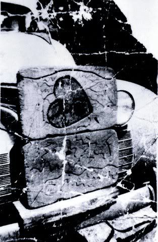
Are my eyes deceiving me (there is no knife visible) or is the picture of the stone maps on the bumper poor quality? Hmmm.
buscar
There's gold in them thar stories and that's where most of it is.
Are my eyes deceiving me (there is no knife visible) or is the picture of the stone maps on the bumper poor quality? Hmmm.
buscar
There's gold in them thar stories and that's where most of it is.
-
Joe Ribaudo
- Expert
- Posts: 5453
- Joined: Tue Sep 17, 2002 10:36 pm
Dagger......
Good Morning Larry,
You and I discussed this back in January of 2006. Nothing has changed in those three years. The dagger does not appear in Dr. Glover's picture.
What it does look like, is that someone took an eraser to the picture that Thomas got his negative from and removed the dagger. Now it's also possible, that there was no dagger on the original stone, and it has been added at a latter date. There are many reasons to assume it was on the original map.
The dagger's point rests on Parker Pass. That is the beginning of one of the trails to the final location, or end of the Stone Map Trails. The arrow on the hilt points to another way to reach the final location and takes you past one of the high points that are locator points. That would be the north side of Tim's Saddle, which the arrow points to.
Those locator dots are important, because they allow you to pin-point/triangulate various landmarks on the map, which in turn authenticates its relevance to that specific location in the Superstition Mountains........to the exclusion of any other place.
Once you draw that dagger on your Topo, placing the point on Parker Pass and the arrow through Tim's Saddle, the rest of the layout of the Stone Maps will become obvious. One of the other locator dots ends up at the highest point on Bluff Spring Mountain. The other is the lower hill on the northeast end of Black Top Mesa. Draw lines between those three places on your Topo, and you will be able to see a clearer picture of why those points are important.
If you draw your line between the Bluff Spring locator dot and the Tim's Saddle locator dot.........on the Stone Maps themselves, you will notice that it goes through the circle in a circle. That crossing takes place in Little Boulder Canyon, which is plainly marked on the Stone Maps. From any of the high points in that area, you will be able to see the triangle.
The trail over from West Boulder, below Tim's Saddle, starts at the top of the one (1) on the Stone Maps and ends in the triangle, which is located in the center of the heart. I have shown the picture of the heart, which that trail leads......directly to.
What I have just written will be obvious to anyone who lays the map out on a Topo, and searches for the heart. Obvious to anyone, except everyone who has decided it is somewhere else.
Take care,
Joe

Those horse and priest photos sure look a lot more authentic than the one's I've seen. I'm seeing some serious differences in some of the markings too, which could dramatically change a seekers course of direction.
Randy Wright
Hobbiest LDM seeker
Mesa, AZ
"I don't care if it has electric windows. I don't care if the door gaps are straight, but when the driver steps on the gas I want him to piss his pants."
Enzo Ferrari
Hobbiest LDM seeker
Mesa, AZ
"I don't care if it has electric windows. I don't care if the door gaps are straight, but when the driver steps on the gas I want him to piss his pants."
Enzo Ferrari
Location
Assuming a stream running west at the top in the heart trail map
along with the mountains that are east to west and close to parallel
with the Salt River, the only place I see on a topo map is above
Tortilla Flats and to the east of Canyon Lake.
The stream that drains into the end of Canyon Lake has another
that drains into it near its mouth from the south-may be Bolder
Canyon? Which could inter the heart about where the 1 is ,and
about west of Geronimo Head.
Didn't check the scale, so you may want to scratch Geronimo Head.
Thanks Joe for the bumper picture. It is intriguing!
billb
Checked them out today and had a nice visit with Greg 2 booths over.
Pedro is visible with the naked eye, but it is very faint and I wouldn't see it if I didn't know it was there. Most discrepancies are just the angle of the lighting and bad photography. They had glass up and you could only see one side of each map: the trail maps, the trail map on the heart and the horse side. No one manned the booth, so I should have told Greg to run home for his replicas and switched them out.
Still, I think they are 19th century and everytime I look at them I just feel that much stronger about it.
Greg pointed out all the dings and scatches from each time they handle them. Either they are softer than we think or the Flagg folks like bashing them around.
"Be Careful of What You Do Before A Lie Becomes The Truth"
That's weird, I don't remember seeing it on the caller ID. Oh well
I'll call ya soon! Weather is getting really nice
I'll call ya soon! Weather is getting really nice
Randy Wright
Hobbiest LDM seeker
Mesa, AZ
"I don't care if it has electric windows. I don't care if the door gaps are straight, but when the driver steps on the gas I want him to piss his pants."
Enzo Ferrari
Hobbiest LDM seeker
Mesa, AZ
"I don't care if it has electric windows. I don't care if the door gaps are straight, but when the driver steps on the gas I want him to piss his pants."
Enzo Ferrari
End of the Trail
The knife ,on the trail map,could be a sharp knife like ridge. The only
other marked place, other than the X's along the trail, is the upside down U. If there was a continuous line under it, you would have a sunrise or sunset. But the way it is, means covered over.
It maybe an arch or it maybe a cave, but it also may mean buried.
The end of the trail is probally a good place to camp with maybe a dependible water supply. The End of the Trail is the best place from which
to start this treasure hunt.
Maybe,
billb
upside down u
I was just looking at that upside down U. Could maybe represent a box canyon. Just a thought. 
Shhh...........Ok now bite me!